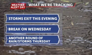
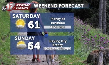
Why are nocturnal tornadoes so dangerous?
Nocturnal tornadoes, or tornadoes that come at night, make up roughly 38 percent of all tornadoes in the United States.
Continue ReadingNocturnal tornadoes, or tornadoes that come at night, make up roughly 38 percent of all tornadoes in the United States.
Continue ReadingTONIGHT: Mostly cloudy with patchy fog developing late into Wednesday morning. Lows in the upper 50s. TOMORROW: Partly to mostly cloudy with morning fog. Highs in the upper 60s to around 70. EXTENDED: Skies begin to break up a bit by Thursday, allowing temperatures to jump back into the low to mid-70s. The pattern begins
Continue ReadingTUESDAY: Clouds could thin, but they will continue to be a nuisance as we move through the day. Highs will be near 70 degrees today, and we do have a slight chance to see some spotty light rain through the afternoon. TONIGHT: Mostly cloudy skies stick around overnight with lows falling into the upper 50’s. EXTENDED: We could
Continue ReadingTUESDAY: It’s shaping up to be a fairly similar day as yesterday. Those pesky light rain chances look to stick around but don’t appear to be anything heavy. Temperatures look to get back into the mid to upper 60’s with winds not as breezy as yesterday and might even work some sun in. TONIGHT: Mostly
Continue ReadingTONIGHT: Mostly cloudy, few sprinkles, 53. TOMORROW: Mostly cloudy with sprinkles possible, highs in the upper 60s. EXTENDED: Stubborn clouds are slow to exit the next few days thanks to slow moving low pressure centered across the upper Midwest. As this finally retreats east by mid-week, we’ll see clouds begin to clear a bit and
Continue ReadingMONDAY: We’re tracking a cloudy and cool day with highs stuck in the low 60’s today. We could see some mist throughout the day that will have minimal impact on our day. TONIGHT: Clouds persist, and lows will fall into the low 50s. EXTENDED: We can’t completely rule out some sprinkles throughout the next few days, but
Continue ReadingMONDAY: Cloudy and cool day with highs stuck in the low 60’s today. This same system we’ve been tracking this weekend isn’t quite done as some light sprinkles will be possible. Best chances to use that umbrella will be east of HWY 63, but everyone has the chance. Those breezy conditions that moved in yesterday
Continue ReadingTONIGHT: Partly cloudy skies will become mostly cloudy by sunrise. Temperatures will be a bit chilly, in the low 50s. MONDAY: Clouds and chillier temperatures will be the main feature Monday. We’ll struggle to get out of the 50s with a gusty northwesterly wind. We also can’t rule out a few spot sprinkles throughout the day–
Continue ReadingTODAY: Many of us east of Highway 54 are waking up to some rainfall this morning. As we progress through the morning, we’re expecting another line of showers and maybe even storms to push through the area before we begin to dry out. This afternoon will be breezy but less humid, and clouds will start to
Continue ReadingTONIGHT: Spotty storms will continue overnight, no severe weather is expected. Temperatures drop into the 60s. SUNDAY: Showers and storms are possible early in the morning, especially east of HWY 63. Most of us will dry out by lunch time, with breezy and cooler conditions for the afternoon hours. Temperatures will be in the upper
Continue ReadingTODAY: We’ll be waking up to cloudy and dry conditions, but rain is not too far off. Scattered storms will start to move into the area this afternoon, and a few of these storms could be strong. Isolated gusty conditions and small hail are not out of the question, but they won’t be the norm
Continue ReadingTONIGHT: Mostly cloudy and mild with lows in the low 60s. TOMORROW: Scattered to widespread showers and thunderstorms. Some storms may bring heavy downpours, isolated small hail, and brief gusty winds. EXTENDED: This cold front that brought our Thursday night storms will lift back north on Saturday and stall out through the day, triggering another
Continue ReadingTHIS AFTERNOON: Sprinkles are possible near the Lake of the Ozarks this afternoon. Temperatures will hold in the upper 60s, clouds will hold strong for most of the region. A few peeks of sunshine are possible after 5pm. TONIGHT: Partly cloudy skies continue and temperatures rise overnight as a warm front lifts through. That front could
Continue ReadingFRIDAY: Showers will start to dwindle throughout the morning. Most of us will be stuck with the clouds today, but may see a few peeks of sunshine this afternoon. Temperatures will get back into the middle 70’s. TONIGHT: Most of us look to stay dry overnight with lows falling back into the low 60’s. EXTENDED:
Continue ReadingThursday Night Update: A line of strong storms capable of producing damaging winds is pushing into our far northern counties along Highway 36 and will continue to pose a damaging wind and large hail threat into the overnight hours. A Severe Thunderstorm Watch is in effect until 5AM for areas along and west of Highway
Continue ReadingTONIGHT: Scattered strong storms early, with a line of damaging winds and heavy rain expected late into the overnight hours. Rainfall could amount to 2-3″. Lows remain in the lower 60s. TOMORROW: Mostly cloudy with a few spot showers or storms. Highs in the upper 70s. EXTENDED: The wavering cold front will retreat back north
Continue ReadingTHIS AFTERNOON: We’re tracking thunderstorms popping up into the evening. Temperatures will be mild in the upper 70s– it will feel fairly humid too. For the latest timing and threats on storms tonight, head over to the Stormtrack Insider Blog. TONIGHT: Storms look to break out along a frontal boundary and slide in around 8-9PM. They’ll continue to
Continue ReadingTHURSDAY: Showers possible early north of I-70, becoming quite warm with highs in the upper 70s to around 80 degrees. A few scattered strong storms are possible in the afternoon, with more widespread severe storms by evening. For the latest timing and threats on storms tonight, head over to the Stormtrack Insider Blog. TONIGHT: Storms
Continue ReadingTONIGHT: Mostly cloudy with scattered showers and storms possible. Lows in the low 60s. TOMORROW: Showers possible early, becoming quite warm with highs in the upper 70s to around 80 degrees. A few scattered strong storms are possible in the afternoon, with more widespread severe storms by evening. EXTENDED: Instability will increase across the area
Continue ReadingTHIS AFTERNOON: A warm front lifting north is sparking off showers and a few thunderstorms. Expect temperatures in the mid 50s rising into the low 60s by evening. TONIGHT: Temperatures hold in the upper 50s and low 60s overnight. They may even rise a degree or two through sunrise. It will be muggy by morning. EXTENDED: It will
Continue Reading