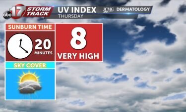
Thursday’s UV index and pollen tracker
The UV index will be slightly lower tomorrow with morning rain and clouds. Pollen levels remain low.
Continue Reading The UV index will be slightly lower tomorrow with morning rain and clouds. Pollen levels remain low.
Continue Reading
This upcoming fall deer and turkey seasons, hunters across many mid-Missouri towns will need to pay extra close attention to changes in regulations brought on by the Missouri Department of Conservation. Boone, Audrain, Howard, Osage, Maries and Saline counties have all been added to the Chronic Waste Disease (CWD) management zones . Starting July 1st, there
Continue Reading
THIS AFTERNOON: Storms are possible again this afternoon toward I-44 and the Lake with the threat of strong winds. Flooding will be a concern from any storms after parts of Mid-MO picked up several inches early Wednesday. TONIGHT: Rain coverage increases tonight keeping the risk of flooding into the early morning. Heavy downpours and lightning
Continue Reading
TODAY: After rain ends around sunrise, we’ll have some dry time. Skies may allow a few peaks of sunshine through an otherwise mostly cloudy sky before we become overcast again this afternoon. TONIGHT: A cold front, the one that brough last night’s storms, will settle near I-44. Showers and storms will return along the front,
Continue Reading
TONIGHT: Increasing clouds with showers and storms likely. Some could be strong with gusty winds, especially north of I-70. Rainfall amounts between 1-2″ possible. Lows in the lower 70s. TOMORROW: Spotty showers early, followed by mostly cloudy skies. Highs in the upper 80s with a heat index in the mid-90s. A few strong storms with
Continue Reading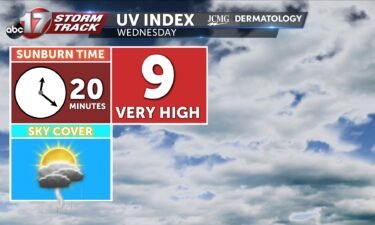
Wednesday’s UV index will be high despite morning clouds and a few showers. Pollen levels remain low through the weekend.
Continue Reading
TODAY: Tuesday will be notably warmer than Monday. Temperatures reach into the 90s, with enough humidity to have us feeling like low triple digits in the afternoon. TONIGHT: Storms return from the north along a cold front after 8 p.m. near Brunswick and Macon. At this point, we’ll have a chance for strong to severe
Continue Reading
TODAY: Tuesday will be notably warmer than Monday. Temperatures reach into the 90s, with enough humidity to have us feeling like low triple digits in the afternoon. TONIGHT: Storms return from the north along a cold front after 7 p.m. near Brunswick and Macon. At this point, we’ll have a chance for strong to severe
Continue Reading
TONIGHT: Decreasing clouds and warmer with lows falling into the upper 60s. TOMORROW: Mostly sunny, hot, and breezy with highs in the mid-90s with a heat index between 100-104 by late afternoon. EXTENDED: A warm front lifts through the region tonight into tomorrow, allowing much warmer air to filter in as highs reach the 90s
Continue Reading
After a cool start to the week, we have an active and hot few days shaping up as we get closer to Independence Day. Winds shift back to the south tonight into Tuesday as a warm front lifts north, sending dew points back into the lower 70s. We’ll notice the increase in humidity early on
Continue Reading
In the past 48 hours we have watched tropical Storm Beryl transition into a category four hurricane with winds sustained up to 150 mph. Beryl is setting records as the strongest early season hurricane seen. This hurricane is currently moving to the west at 21 mph and will remain a category four hurricane for at
Continue Reading
The UV index will be high with a sunburn time around 20 minutes on Tuesday. Pollen levels remain low.
Continue Reading
TODAY: Monday is a mild and dry start to what will become an increasingly warm and active week. Temperatures top out just near 80, with low humidity, which will have us feeling pleasant under partly cloudy skies today. Chances of showers increase into the afternoon hours before drying up this evening. TONIGHT: Skies clear overnight,
Continue Reading
TODAY: Monday is a mild and dry start to what will become an increasingly warm and active week. Temperatures top out just near 80, with low humidity, which will have us feeling pleasant under partly cloudy skies today. A limited chance for showers arrives around 11 am and lingers into the early afternoon before drying
Continue Reading
CNN By Elizabeth Wolfe and Mary Gilbert, CNN (CNN) — Hurricane Beryl is roaring through the Windward Islands as an extremely dangerous Category 4, delivering violent winds, intense rainfall and life-threatening storm surge after making landfall Monday. Beryl made landfall shortly after 11:00 a.m. EDT on Grenada’s Carriacou Island in the Caribbean Sea with maximum
Continue Reading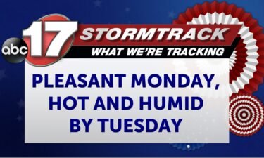
TONIGHT: Mostly clear with a few clouds and lows in the lower 60s. TOMORROW: Mostly sunny with low humidity and a slight breeze. Highs in the upper 70s to around 80. EXTENDED: It’s been a gorgeous day with high pressure keeping us much cooler and more comfortable to close out the weekend. Below average temperatures
Continue Reading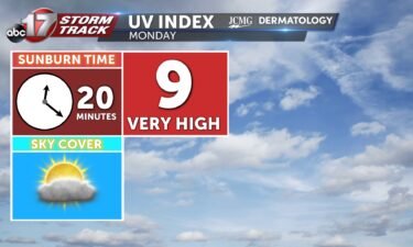
The UV index will be high despite increasing clouds in the afternoon. Pollen levels also stay low through the week.
Continue Reading
TODAY: Temperatures are much cooler today as highs only rise to the low 80s. Plenty of sunshine and lack of moisture spell out a beautiful end to the weekend. TOMORROW: Monday is still nice in the 70s with a few added clouds from rain out west. This rain likely fizzles out in central Missouri thanks
Continue Reading
TONIGHT: I’m tracking the possibility for isolated strong to severe storms south of I-70 becoming present by 5-7 PM. If storms do become severe, wind gusts up to 60 mph and hail stones up to 1″ in diameter will be the most likely threats. These storms will continue to shift south through the overnight hours
Continue Reading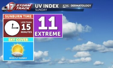
The UV Index on Sunday will be an 11, which is extreme. This means it will take less than 15 minutes to receive a sunburn without the proper protection. Pollen levels will be kept to a minimum into next week.
Continue Reading