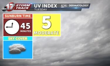
Tuesday’s UV index and pollen tracker
The UV index will be low tomorrow with rain in the area, and pollen levels stay low all week.
Continue Reading The UV index will be low tomorrow with rain in the area, and pollen levels stay low all week.
Continue Reading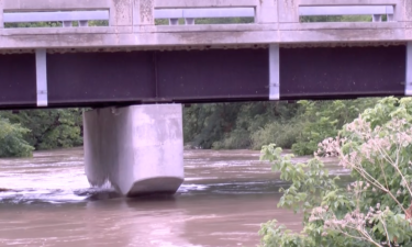
COLUMBIA, Mo. (KMIZ) Mid-Missouri has seen an increase in flooding since the beginning of the month. According to the National Weather Service, Columbia has received almost nine inches of rain since July 1. The National Weather Service’s Turn Around Don’t Drown campaign has been referenced by officials since Columbia has seen flash flooding and water
Continue Reading
TODAY: Scattered showers push through Mid-Missouri throughout the day as highs reach into the lower 80s. TONIGHT: Overnight lows cool to the upper 60s as showers and storms push into the area from Hurricane Beryl’s remnants. Flooding remains a concern as this system drops high rainfall rates through the region on already saturated grounds. EXTENDED:
Continue Reading
TONIGHT: I’m tracking a line of storms that will move east into more central portions of Missouri by 4-7 PM. Highest concern with these storms are lightning and heavy downpours, but some storms could produce gusty winds and small hail stones. TOMORROW: I’m tracking storms dissipating throughout the morning but a mix of clouds and
Continue Reading
JEFFERSON CITY, Mo. (KMIZ) A Red Cross volunteer from the Central and Northern Missouri Red Cross Chapter is driving an Emergency Response Vehicle to Texas as Tropical Storm Beryl approaches. According to the news release, the volunteer left Sunday morning from the chapter office in Jefferson City. The Red Cross says other Missouri volunteers are
Continue Reading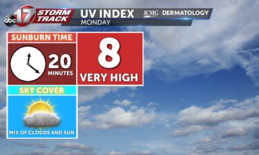
Monday will have a UV Index of 8 because of a mix of clouds and sunshine throughout the day. This means that it will only take 20 minutes to receive a sunburn without proper protection. Pollen levels will be low over the start of next week.
Continue Reading
TODAY: The morning starts dry with temperatures racing to the 80s by noon. Scattered showers and thunderstorms develop in western Missouri midafternoon and this activity tracks east through the evening. Up to an inch of rain is possible today and flood impacts should remain low. TOMORROW: Rain chances linger most of Monday but there will
Continue Reading
BOONE COUNTY, Mo. (KMIZ) Missouri Task Force One is heading to Texas Saturday morning, ahead of Tropical Storm Beryl, according to a social media post from the Boone County Fire Protection District. The Federal Emergency Management Agency activated the task force to deploy as a type three team, consisting of 37 members, plus 10 ground
Continue Reading
TONIGHT: I’m tracking mostly clear to partly cloudy sky conditions as temperatures drop into the mid 60s by the end of the night. Winds will shift into the SE at 5-7 mph with gusts up to 10 mph. TOMORROW: I’m tracking a dry start to the morning with shower/storm chances beginning in the afternoon hours.
Continue Reading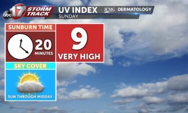
Before rain chances and clouds return in the afternoon, a UV index of 9 is expected. This means it will only take 20 minutes to receive a sunburn without proper protection. Pollen levels will be low over the start of next week.
Continue Reading
TODAY: The weekend kicks off beautifully with the mid-80s and mostly sunny skies. Winds will be lighter out of the west. TOMORROW: Sunday also starts dry but scattered showers and storms track in by the afternoon and evening. Temperatures remain warm ahead of the rain in the 80s. EXTENDED: Monday looks even wetter with rain
Continue Reading
TONIGHT: Overnight lows cool to the lower 60s with winds out of the northwest. Skies remain mostly clear. TOMORROW: Saturday welcomes highs into the mid-80s with mostly sunny skies. Winds remain out of the west at 4-8 mph. EXTENDED: Sunday becomes partly cloudy with highs into the upper 80s. Sunday late afternoon welcomes scattered shower
Continue Reading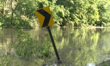
COLUMBIA, Mo. (KMIZ) The U.S. Coast Guard has closed the Missouri River between St. Charles and Kansas City due to dangerous conditions. According to a notice from the Coast Guard, the river from mile marker 27 to mile marker 366 is closed due to “high water and threat of any boat wake to damage sandbag
Continue Reading
THIS AFTERNOON: Highs reach the low 80s with a northwest breeze around 10-15 mph. It will feel very comfortable outside after a drop in humidity. TONIGHT: Skies remain mostly clear tonight with temperatures falling into the low 60s. EXTENDED: Saturday is a near repeat with a few added degrees in the afternoon. Low pressure and
Continue Reading
TODAY: Friday is pleasant, with increasingly bright skies, and low humidity. Highs are forecast in the low 80s with a northwest breeze around 10-15 mph. TONIGHT: Overnight into early Saturday, skies remain mostly clear, with temperatures falling into the low 60s amid increasingly calm west winds. EXTENDED: High pressure keeps things calm and dry, with
Continue Reading
Two people clinging to tree branches were pulled from floodwater at Three Creeks Conservation Area on Thursday afternoon.
Continue Reading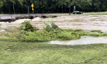
Severe flash flooding had multiple roads in Fulton blocked off Thursday morning.
Continue Reading
Isolated storms have started to develop across the Missouri-Iowa border and have quickly become intense
Continue Reading
TONIGHT: Thursday is an ABC 17 Stormtrack Weather Alert Day for potential severe storms this evening. The first of these storms arrives at 9-10 p.m. for Sedalia, Warsaw, and the Lake area. Storms will then track east to I-44 around midnight, with storms heading out late overnight. Jefferson City and places northward have a lower chance
Continue Reading
The companies insuring against Mother Nature are finding it increasingly harder to do so in a changing climate. Bigger wildfires, stronger hurricanes, and more severe storms all put more strain on the industry protecting our property. But the future looks to hold more disasters that will cost even more money to bounce back from. The
Continue Reading